智慧城市系列课程项目案例库建设——数字孪生城市案例
Cases | 案例
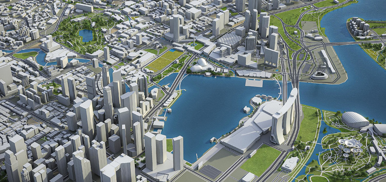
1.Virtual Singapore - Building a 3D-Empowered Smart Nation
Abstract: Virtual Singapore is a dynamic 3D city model and collaborative data platform, The Virtual Singapore platform which acts as a digital twin of the city., It enables urban planners to test solutions without taking too many risks – especially relevant in the case of Singapore given that land scarcity doesn’t leave any space for risky experiments. The SGD 73 million project is led by the National Research Foundation (NRF) and is based on the 3D topographical data from SLA, which was collected as part of the 3D National Mapping project. The platform also integrates geometric and image data from different public agencies, 2D data and information from existing geospatial and non-geospatial platforms such as OneMap, People Hub, and Business Hub, as well as legacy and real-time data from sensors deployed across Singapore as part of the Smart Nation initiative. NRF uses Dassault System’s smart city offer called 3DEXPERIENCity to create a dynamic 3D digital model of the city, and connect all stakeholders in a secure, controlled environment.
开发主体单位\开发年份: Singapore Land Authority (SLA)\2014
核心概念\主题\地区\尺度: 3d modeling\土地利用\Singapore\国家级
网址:https://www.geospatialworld.net/prime/case-study/national-mapping/virtual-singapore-building-a-3d-empowered-smart-nation/
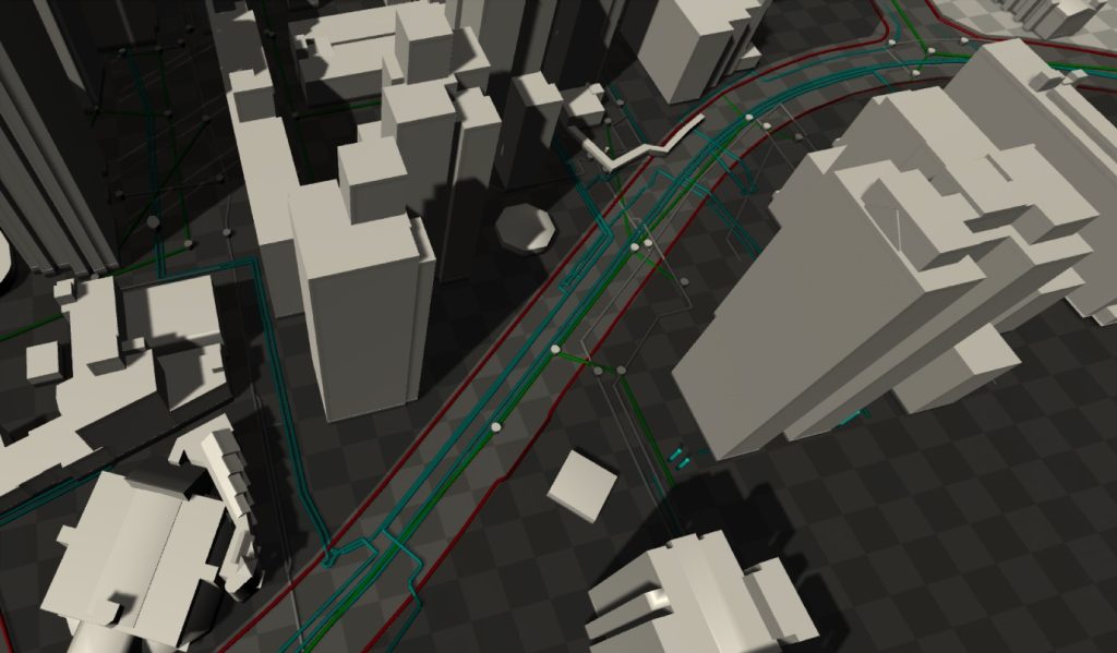
2.Digital Underground
Abstract: Singapore is going underground. In March 2019, the Urban Redevelopment Authority of Singapore unveiled the external pageDraft Master Plan 2019 to guide Singapore’s development in the future. For the land-scarce city state, the use of underground space is a key strategy to create space for its growing needs. As a consequence, Singapore’s already heavily developed underground space is bound to become more and more congested, with many activities and developments expected to take place.
开发主体单位\开发年份: Singapore-ETH Centre (SEC)\2019
核心概念\主题\地区\尺度: utility infrastructures\基础设施\Singapore\国家级
网址:https://sec.ethz.ch/research/digital-underground.html
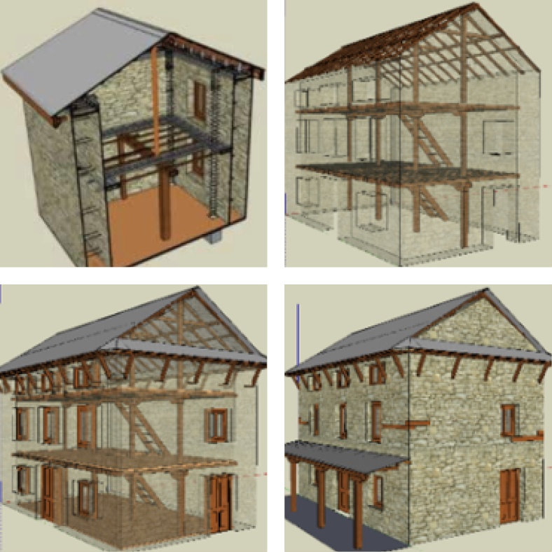
3.Reality Capture Solutions to Rebuild Infrastructure in Quake-hit Nepal
Abstract: Nepal suffered from a 7.8 magnitude earthquake in April 2015. In addition to the loss of lives, there was severe damage to housing and school infrastructure, which displaced roughly 2.8 million people. To rebuild the infrastructure in the region, and to ensure that future disasters do not lead to loss of lives and property of such great proportions, Build Change, which has the expertise in designing disaster-resistant houses and schools, proposed the idea of retrofitting the damaged homes. Understanding the severity of the problem, the National Reconstruction Authority of Nepal, approved the retrofitting type-design submitted by Build Change to seismically strengthen their earthquake-damaged houses (still standing but cracked and unsafe for occupancy).
开发主体单位\开发年份: Build Change\2015
核心概念\主题\地区\尺度: 3d modeling\基础设施\Nepal尼泊尔\国家级
网址:https://www.geospatialworld.net/prime/reality-capture-solutions-to-rebuild-infrastructure-in-quake-hit-nepal-2/
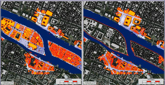
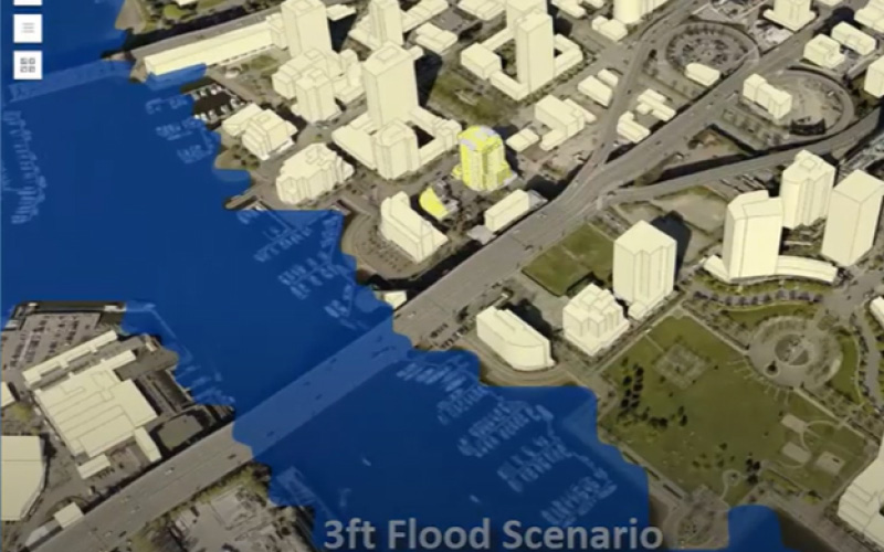
4.Lisbon’s City Scale Digital Twins for Flood Resilience
Abstract: Lisbon’s City Government uses Digital Twins to develop a drainage master plan to mitigate the risks from rising sea levels and frequent extreme rainfall events.
开发主体单位\开发年份: Lisbon’s City Government\2023
核心概念\主题\地区\尺度: Flood Resilience Models using Digital Twins\洪水模拟\Lisbon里斯本\城市级
网址:https://www.geospatialworld.net/prime/case-study/aec/lisbons-city-scale-digital-twins-for-flood-resilience-2/
5.3D Reconstruction of Vancouver City for Disaster Management
Abstract: Under the umbrella of the PS-CRIMSON (Public Safety and Crisis Management Service Orchestration) collaboration project, Esri Canada has developed intelligent 3D modeling of urban spaces to support disaster management.
开发主体单位\开发年份: Esri Canada\2020
核心概念\主题\地区\尺度\核心方法: 3D Reconstruction\灾害管理\Vancouver温哥华\城市级\GIS, 3D mapping and IC
网址:https://www.geospatialworld.net/prime/case-study/aec/3d-reconstruction-of-vancouver-city-for-disaster-management/
6.Artificial Intelligence Helps Meet Covid Safety Challenges in London Building Project
Abstract: The Mace Group utilized an Artificial Intelligence (AI) powered building productivity management platform to overcome challenges posed by Covid-19 in the No. 1 Grosvenor Square redevelopment project in Mayfair, London.
开发主体单位\开发年份: Mace Group\2017
核心概念\主题\地区\尺度\核心方法: Artificial Intelligence \项目管理\London伦敦\地块级\Artificial Intelligence
网址:https://www.geospatialworld.net/prime/case-study/aec/artificial-intelligence-helps-meet-covid-safety-challenges-in-london-building-project/

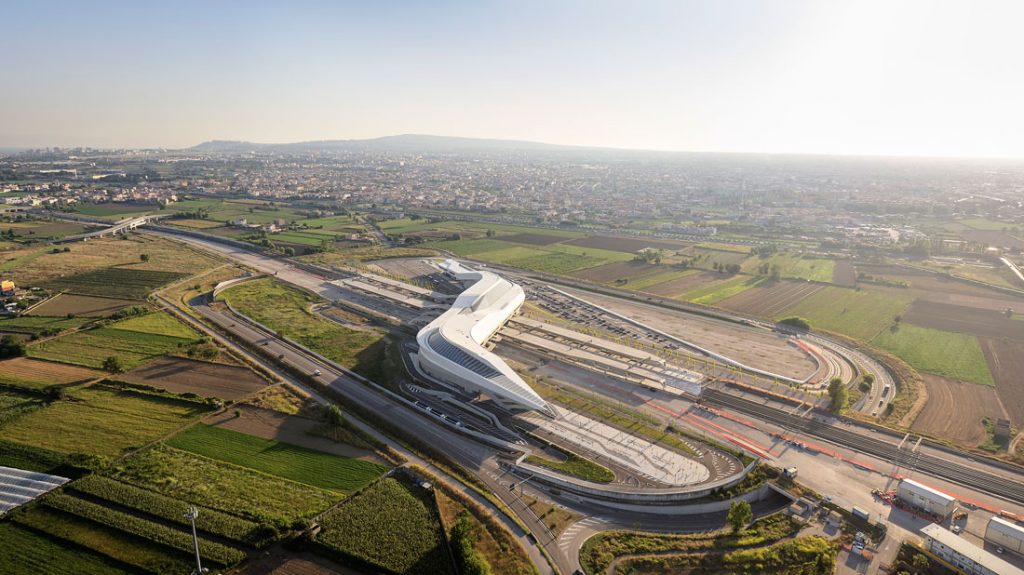
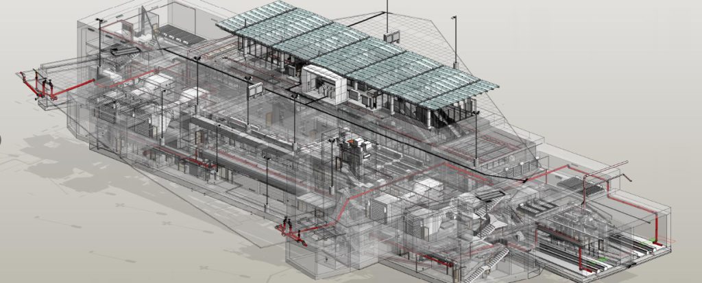
7.Digital Twin for Delivering High-speed Rail Project in Italy
Abstract: Italferr, an Italian State Railways Group engineering firm, used point cloud data from LiDAR with BIM to create a Digital Twin model of the entire high-speed rail project on the Napoli-Bari rail route.
开发主体单位\开发年份: Rete Ferroviaria Italiana (RFI)\2027
核心概念\主题\地区\尺度\核心方法: BIM workflows for integrated lifecycle solutions\交通\Italy意大利\国家级\3D BIM
网址:https://www.geospatialworld.net/prime/case-study/aec/digital-twin-for-delivering-high-speed-rail-project-in-italy/
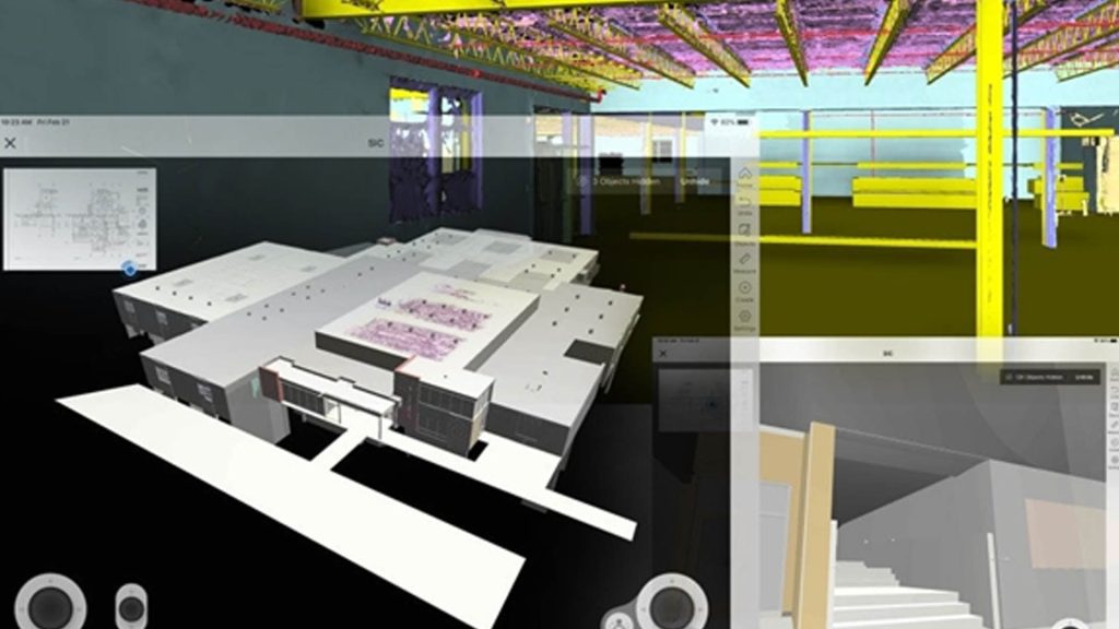
8.Virtual Design and Construction Speed Project Delivery of Virginia Innovation Center
Abstract: Laser scanner-generated point cloud datasets were efficiently converted into segmented mesh models, which were seamlessly shared among project stakeholders for enhanced productivity.
开发主体单位\开发年份: Howard Shockey & Sons, Inc.\2021
核心概念\主题\地区\尺度\核心方法: 3d modeling\建筑设计\Winchester温彻斯特\地块级\BIM, Laser Scanning
网址:https://www.geospatialworld.net/prime/case-study/aec/virtual-design-and-construction-speed-project-delivery-of-virginia-innovation-center/
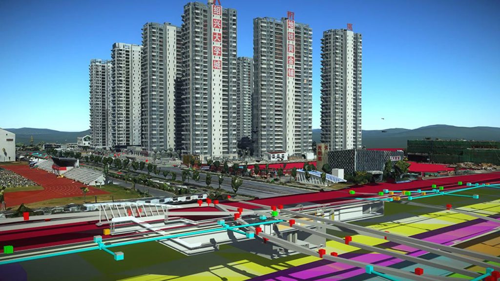
9.Digital Twin and Automation Streamline Workflow on Chinese Metro Rail Project
Abstract: The use of GeoBIM, 4IR and immersive technologies in the construction of an urban transit line project in Shaoxing, China, helped the contractor save USD 1.53 million (CNY 10 million) at the design stage itself.
开发主体单位\开发年份: POWERCHINA Huadong Engineering Corporation Limited (HDEC)\2021
核心概念\主题\地区\尺度\核心方法: Digitization and Collaboration\地铁建设\Shaoxing绍兴\城市级\GeoBIM, 4IR and immersive technologies
网址:https://www.geospatialworld.net/prime/digital-twin-and-automation-streamline-workflow-on-chinese-metro-rail-project/
10.BIM and Common Data Environment on the LA Regional Connector Transit Corridor Project
Abstract: 3D visualization of proposed designs of the stations enabled the project stakeholders to save per station construction cost by USD 3 million to USD 15 million.
开发主体单位\开发年份: Skanska USA Civil Western California District Inc.\2021
核心概念\主题\地区\尺度\核心方法: 3D visualization of proposed designs of the stations\公共设施\The Los Angeles洛杉矶\地块级\BIM,3D Printing
网址:https://www.geospatialworld.net/prime/case-study/aec/bim-and-common-data-environment-on-the-la-regional-connector-transit-corridor-project/
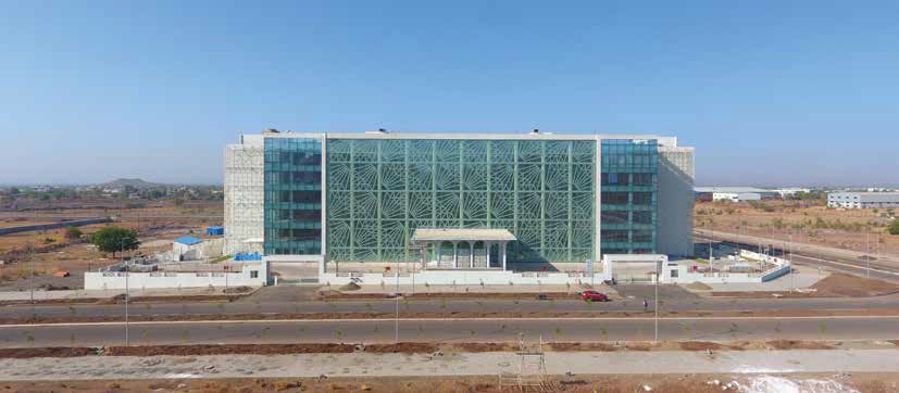
11.The Aurangabad Industrial City (AURIC)
Abstract: The Aurangabad Industrial City (AURIC) is among India’s first well-planned, greenfield industrial Smart Cities, which has been developed in an area of 10, 000 acres, out of which the Bidkin Industrial Area spans 2,487 acres.Working in close collaboration with L&T, Techture used Autodesk AEC solutions (Civil 3D, InfraWorks and Navisworks) to devise the project workflow and provide a clash-free design, along with reliable, accurate and quantitative planning data for the project. This facilitated high-quality design from the pre-construction stage, for water-based utility networks, roads and highway structures.
开发主体单位\开发年份: Larsen & Toubro (L&T)\2022
核心概念\主题\地区\尺度\核心方法: Greenfield industrial Smart Cities\城市建设\Aurangabad奥兰加巴德\城市级\Civil 3D, InfraWorks and Navisworks
网址:https://www.geospatialworld.net/prime/technology-redefines-aurangabad-industrial-city-project/
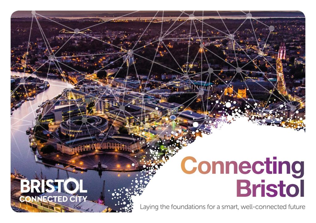
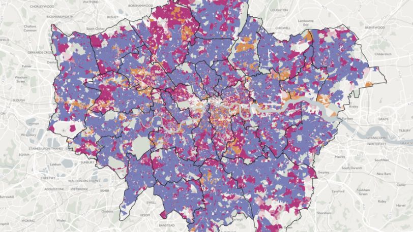
12.Connected London
Abstract: Connected London improves gigabit connectivity across the city by working with boroughs and telecommunications providers. Since 2017 digital connectivity in London has vastly improved from 4 per cecnt of the city had gigabit speeds to 88 per cent and all new developments are required to have a full fibre connection from now on.
开发主体单位\开发年份: GLA\2017
核心概念\主题\地区\尺度: Digital connectivity\数字化\London伦敦\城市级
网址:https://www.london.gov.uk/programmes-strategies/business-and-economy/mayors-priorities-londons-economy-and-business/connected-london
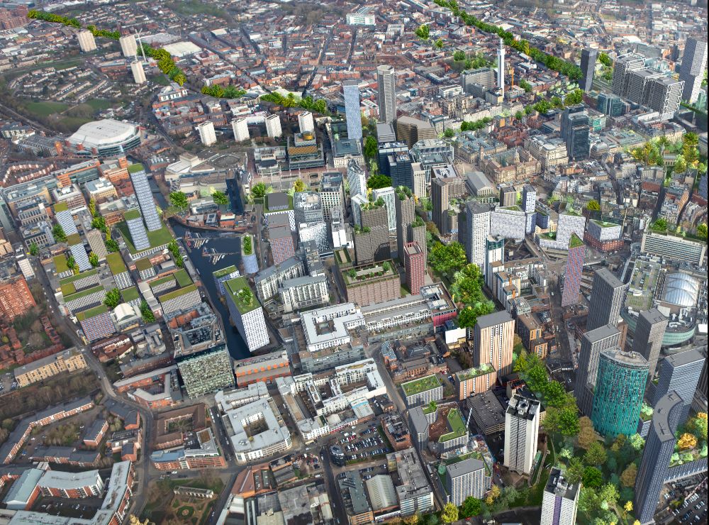
13.Leeds Innovation Arc
Abstract: The West Yorkshire Healthtech and Digital Tech Investment Zone brings together universities, businesses and hospitals to deliver cutting-edge research and develop innovative new health and care technologies, for use in the UK and world-wide.
The investment acknowledges West Yorkshire as a thriving innovation ecosystem. It will accelerate development in Leeds of a £1.5 billion city centre science park – the Leeds Innovation Arc. The Arc stitches together some of the most significant assets in the North of England and will enable unprecedented collaboration between clinicians, entrepreneurs, and academics in Leeds and providing space for healthtech scale-up and start-up businesses.
开发主体单位\开发年份: Health Innovation Leeds\2008
核心概念\主题\地区\尺度: Delivering efficient services using data\智能规划\Manchester曼彻斯特\城市级
网址:https://www.manchesterdigital.com/posts

14.Manchester Digital Development
Abstract: A recent EU report ranked Manchester as the fifth most successful Smart City amongst 240 EU28 cities. The city’s smart initiatives are implemented by the Manchester Digital Development Agency (MDDA) and are in line with the Manchester Digital Strategy launched in 2008. MDDA focuses on initiatives that are ‘people-centred’. These include projects that promote digital inclusion (such as Go ON Manchester and EastServe), enable the development of applications using open data by running Hackathons and improve citizens’ participation in planning the city’s future (through the Manchester Living Lab).
开发主体单位\开发年份: Lisbon’s City Government\2023
核心概念\主题\地区\尺度: Manchester Digital Development Agency\洪水模拟\Lisbon里斯本\城市级
网址:https://www.geospatialworld.net/prime/case-study/aec/lisbons-city-scale-digital-twins-for-flood-resilience-2/

15.Digital Birmingham
Abstract: Digital Birmingham (a council-owned partnership organisation) formed a Smart City Commission in July 2012 and launched the Birmingham Smart City Roadmap in March 2014. The roadmap sets out 49 actions grouped under three main themes: Technology and Place (which involves improving broadband connectivity and sharing open data), People (focusing on digital inclusion, improving citizens’ ICT skills and implementing new business procurement processes) and economy (mainly around digitalising social care, improving energy efficiency and smart mobility).
开发主体单位\开发年份: Digital Birmingham\2012
核心概念\主题\地区\尺度: Smart City Roadmap\数字化\Birmingham伯明翰\城市级
网址:https://digitalbirmingham.co.uk/
16.MK:Smart - Building a Smart City
Abstract: In January 2014, Milton Keynes received a £16 million grant from the Higher Education Funding Council for England (HEFCE) to take forward a Smart City, Big Data (also called MK:Smart) project. Led by the Open University, the project will aim to demonstrate how data gathered from the city’s censored infrastructure and other sources (through the new MK Data Hub) can help better manage utilities and decrease the city’s carbon footprint. The city also hosts the £150 million new Transport City Catapult and is trialling a number of smart initiatives such as installing smart street lighting in order to reduce energy use by 40 per cent.
开发主体单位\开发年份: England (HEFCE)\2014
核心概念\主题\地区\尺度: Smart City and Big Data\智慧城市\Milton Keynes米尔顿凯恩斯\城市级
网址:https://www.mksmart.org/
17.Smart City Bristol
Abstract: Smart City Bristol, launched in 2011, aims to use smart technology to meet its ambition of reducing CO2 emissions by 45 per cent by 2020. The strategy, led by the council’s Smart Cities team, focuses on smart transport, smart energy and smart data and includes pilot projects (such as 3e-Houses and Smart Spaces) which are mostly funded by the EU.
开发主体单位\开发年份: Bristol City Council\2011
核心概念\主题\地区\尺度: Delivering efficient services using data\减碳\Bristol布里斯托尔\城市级
网址:https://www.slideshare.net/Bristolcc/bristol-smart-city-report-7579696